Picture trying to show the full story of a property, event, or construction project from the ground. You may capture beautiful details, but something still feels incomplete. The scale, the layout, and the surrounding context often remain hidden.
This is exactly where aerial visuals begin to outshine traditional shots. A well-planned drone image does more than look impressive. It helps your audience instantly understand space, atmosphere, and value. When used strategically, it transforms the way people connect with your brand and makes your visuals far more memorable.
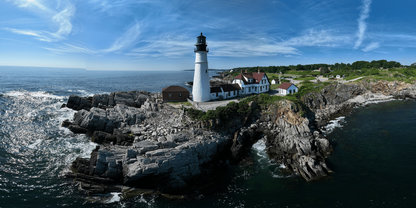
Some visuals need more than detail. They need perspective. Ground-level photography is excellent for showcasing close-up elements such as architectural finishes, people, and textures, but when your goal is to communicate the full setting, drone photography becomes the smarter choice. Imagine a waterfront home in Maine.
A standard front-facing image may beautifully frame the exterior, but it still leaves viewers wondering about the lot size, the surrounding neighborhood, the distance to the shoreline, and the way the property sits within its environment.
An aerial shot answers all of those questions in a single frame. This ability to reveal context immediately is what makes drone visuals so effective. Instead of forcing viewers to piece together multiple images, you give them the full picture at once, helping them engage faster and understand the value more clearly.
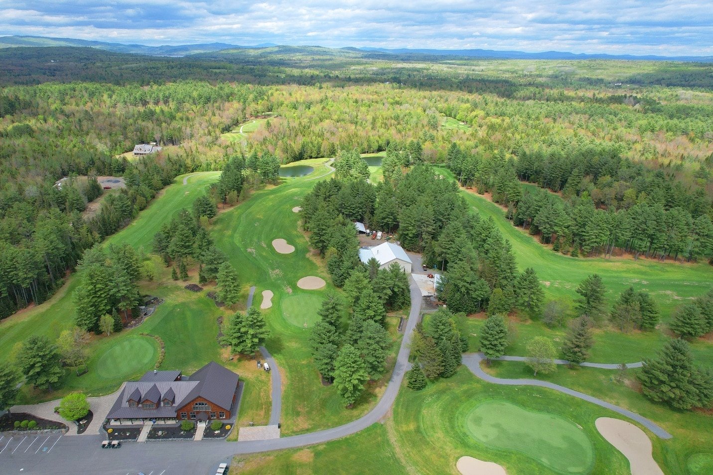
Large estates, commercial properties, resorts, and expansive private homes often lose their full impact when photographed only from the ground. You may capture the front entrance beautifully, but the audience still cannot grasp the scale of the property.
This is where aerial photography services make a dramatic difference. From above, you can showcase the entire footprint, including outdoor amenities, landscaped gardens, parking, access roads, and surrounding scenery. For buyers, investors, and clients, this wider perspective creates confidence because it presents the complete story.
It helps them understand what makes the space special without needing to imagine what lies beyond the frame.
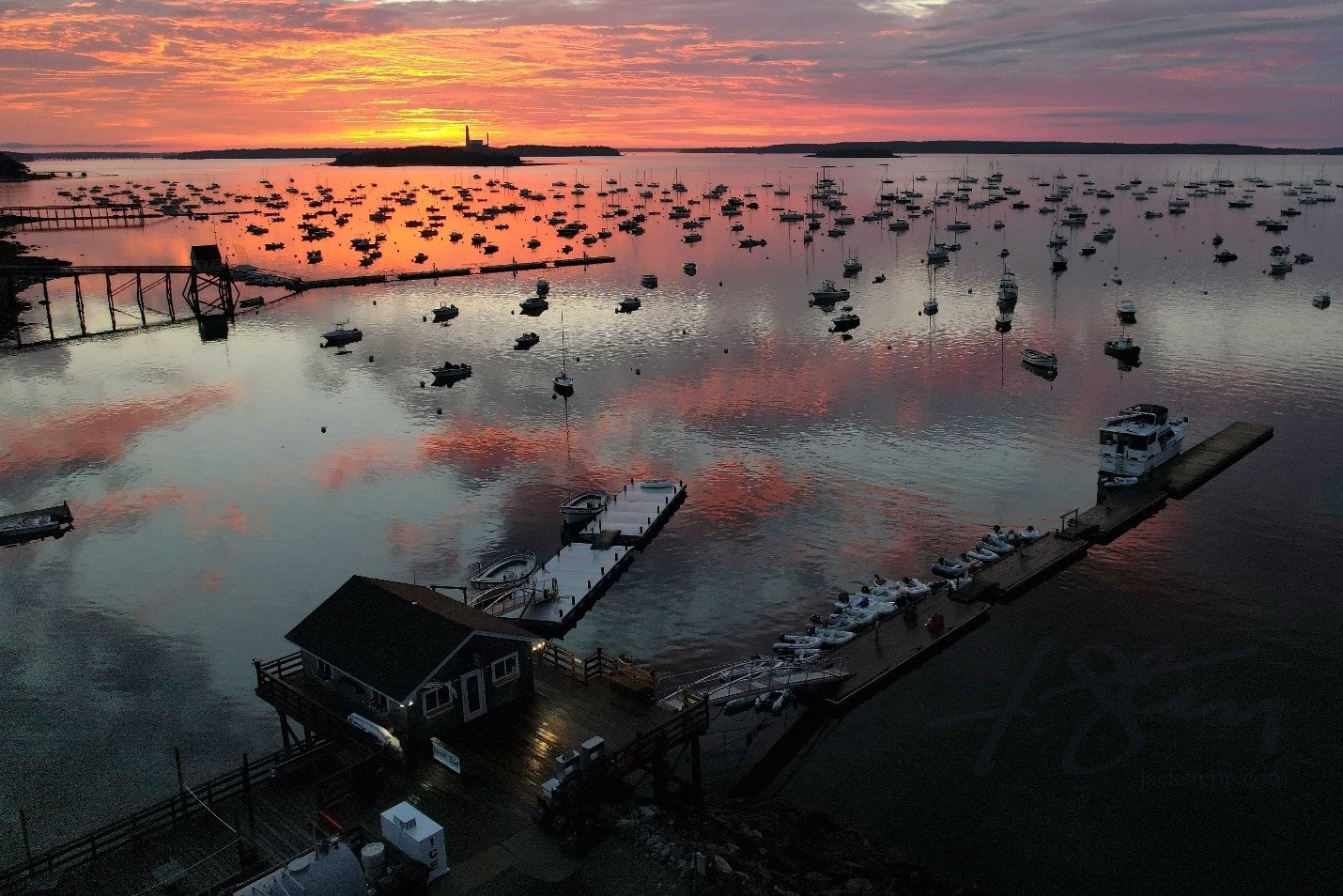
For businesses built around location and scenery, aerial content is one of the most powerful storytelling tools available. Whether you run a wedding venue, hospitality business, vineyard, tourism service, or outdoor event space, drone photography and videography help people feel the location before they ever visit.
A ground-level image may capture the entrance or a specific feature beautifully, but an aerial perspective reveals the surrounding lake, coastline, forest, or mountain backdrop that gives the place its character. This is what makes the visual feel immersive.
People do not simply see the venue. They begin to imagine themselves there, which often creates a stronger emotional response and a deeper connection to your brand.
Events are one of the clearest examples of when aerial visuals outperform traditional media. Ground shots capture expressions and personal moments beautifully, but they often miss the atmosphere that makes an event unforgettable.
This is where high-resolution aerial photography becomes incredibly effective. From above, you can capture crowd energy, venue layout, lighting design, stage setup, and the surrounding environment all in one image. For weddings, festivals, and corporate gatherings, this perspective preserves the scale and feeling of the occasion.
It helps the final visuals feel more cinematic and more emotionally resonant, while also creating strong marketing material for future promotions.
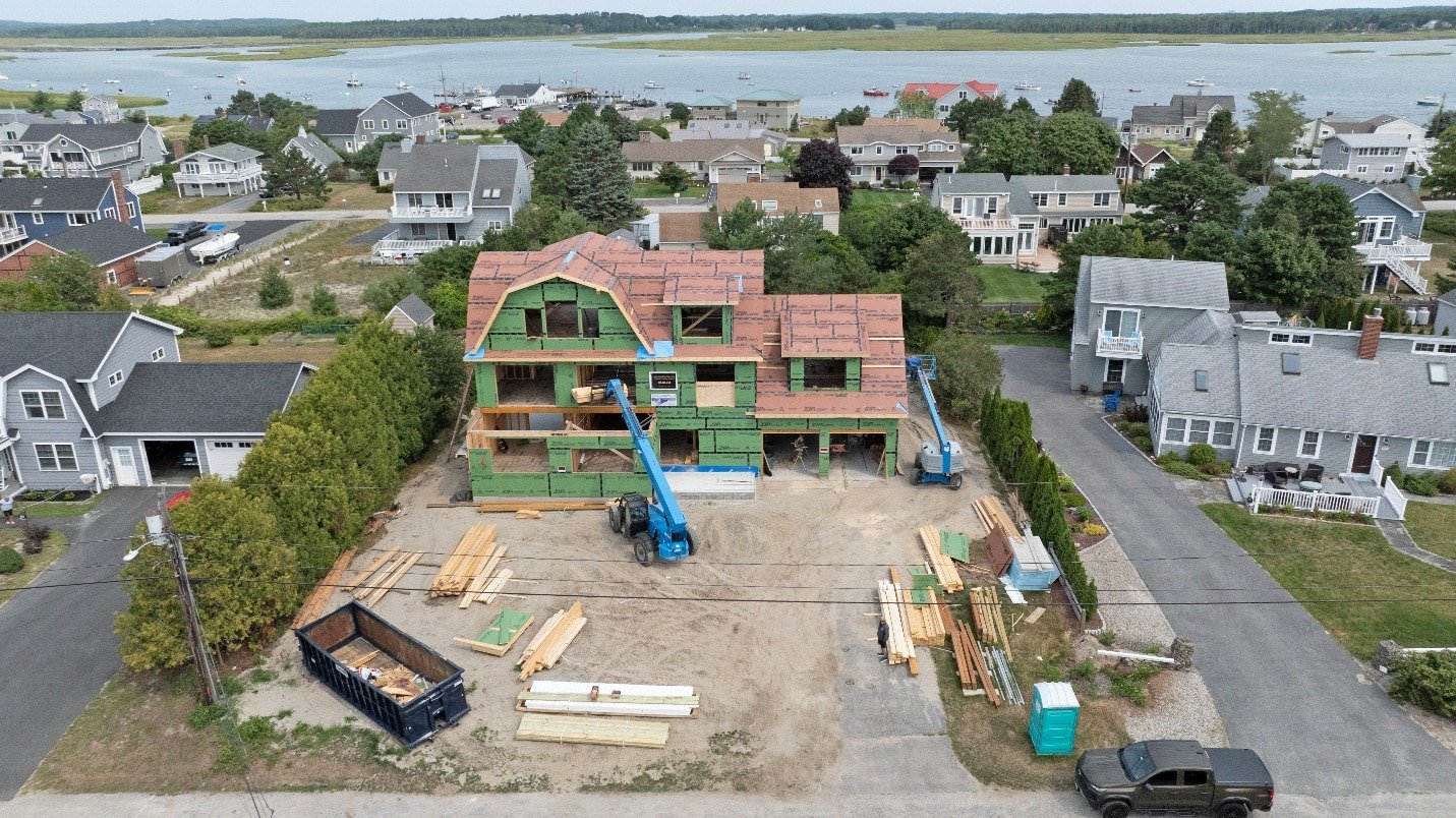
Construction projects need visuals that do more than look polished. They need to communicate progress clearly. Aerial views make it much easier for teams, stakeholders, and clients to understand the overall site layout and track development stages.
Working with a professional drone photographer allows you to capture the full footprint of the site, equipment positioning, completed phases, and areas still under development. These visuals become highly useful for progress reports, investor presentations, internal updates, and marketing.
Rather than relying on multiple disconnected images, one aerial shot can show exactly where the project stands.
Few industries benefit from aerial content as much as real estate. Buyers want context, and that context often influences whether they move forward. This is why drone footage for real estate has become such an effective marketing tool.
Aerial visuals help show lot size, neighborhood layout, nearby schools, water access, landscaping, and overall curb appeal in a way traditional images cannot fully communicate. For premium listings, real estate aerial video tours create a polished first impression that feels elevated and memorable.
They help buyers understand the setting and flow of the property before they ever step inside, which often leads to stronger interest and faster enquiries.
Drone visuals are powerful, but that does not mean ground photography loses its value. In fact, ground shots still remain essential in many situations. Close-up details, interior spaces, portraits, and emotional moments are best captured at eye level because they create intimacy and human connection.
The smartest visual strategy is not about replacing one format with another. It is about understanding when each one serves your goals better. Aerial shots establish scale and atmosphere, while ground visuals create closeness and detail.
Together, they work far more effectively than either approach alone.
The strongest visual campaigns often combine aerial and ground-level content. This hybrid method creates a more complete story. Aerial visuals establish context, location, and scale, while ground shots focus on detail, texture, and emotional moments.
This is exactly why drone marketing videos often perform so well across websites and social media. They can open with a sweeping overhead reveal, then transition into close-up scenes that create connection and trust. This layered storytelling approach feels more cinematic, more professional, and more engaging for your audience.
Aerial content has transformed the way many industries present themselves. Real estate, construction, tourism, hospitality, agriculture, marine services, and events all benefit significantly from elevated perspectives.
For local businesses, drone photography in Maine is especially effective because the surrounding landscape is often part of what makes the offering valuable. Waterfront homes, coastal venues, marinas, and forested properties all gain far more visual impact when shown from above. Similarly, aerial photography services in Maine help businesses showcase location and atmosphere in a way that feels immersive and distinctive.
Many businesses assume aerial visuals are difficult or expensive to incorporate, but they often provide excellent long-term value. One drone session can produce content for listings, websites, brochures, social media, and commercial presentations.
Working with a professional drone photographer in Maine also simplifies logistics because the planning, flight permissions, timing, and technical considerations are handled professionally. This makes the process smooth and accessible, even for businesses using drone visuals for the first time.
Drone visuals should always be captured professionally and within legal guidelines. Airspace restrictions, FAA compliance, weather considerations, and property permissions all play an important role in ensuring safe and lawful operations.
This is why businesses should work with professionals who offer high-resolution aerial photography in Maine and understand the technical and legal requirements. This becomes especially important when using real estate drone photography in Maine, where compliance helps protect both the listing and the business behind it.
The success of aerial content should always be measured through outcomes that matter to your business. This may include increased listing views, longer website engagement, stronger click-through rates, more social shares, or improved enquiry volume.
Aerial visuals often increase time on page because they naturally hold attention longer. When people stay engaged, they are more likely to remember your brand and take the next step.
As powerful as aerial visuals are, there are moments when staying closer to the ground simply works better. Not every story needs height. Sometimes what truly connects with your audience is the detail, the texture, and the human perspective that only eye-level shots can deliver.
Think about moments like:
These moments are intimate, and that intimacy is often lost when viewed from above.
Ground photography excels when your goal is to create emotional closeness. It allows people to feel present in the space.
For different industries, this might mean:
While aerial visuals establish context and scale, ground shots create familiarity and trust. The most effective visual strategy understands that one perspective should not replace the other, but instead complements it.
The strongest visual campaigns rarely rely on a single angle. Instead, they combine aerial and ground-level perspectives to create a fuller story. This hybrid approach is where visuals truly become smarter. You start with the wide, cinematic reveal from above, then guide your audience into the finer details that matter on a personal level.
This is why drone marketing videos often perform so well. A sweeping overhead shot can introduce the setting, whether it is a waterfront property, an event venue, or a commercial site. Then, ground-level footage brings the audience closer by showing the design details, people, and activity within that space. The result feels immersive and polished.
For example, a real estate campaign might begin with an aerial reveal of the entire lot, the surrounding neighborhood, and nearby amenities, then transition into beautifully framed interior shots. This combination gives buyers both context and connection. The same principle applies to event coverage, where aerial footage captures the crowd and venue scale, while ground visuals preserve personal moments and ambiance.
Aerial visuals have changed how multiple industries communicate value. Few tools are as effective at instantly showing context, scale, and atmosphere.
Industries that benefit most include:
Real estate remains one of the biggest beneficiaries. With drone photography in Maine, listings gain an edge by showing:
This is especially important in Maine, where coastal settings, wooded properties, and scenic estates often influence buyer decisions.
Construction and commercial development also benefit from aerial imagery for:
Hospitality and tourism brands use aerial visuals to showcase:
rather than only the building itself.
A common misconception is that drone visuals are difficult or expensive to implement. In reality, they often provide more value than multiple separate shoots from the ground.
One well-planned aerial session can generate content for websites, listings, brochures, social campaigns, and commercial presentations. That means a single shoot can serve multiple business goals at once.
Working with a professional drone photographer in Maine also simplifies the process significantly. From planning the ideal time of day to understanding weather conditions, airspace rules, and site access, experienced professionals handle the logistics for you. This makes the experience seamless, especially if it is your first time using aerial visuals for your business.
In many cases, the return on investment is not just measured in image quality, but in improved engagement, stronger enquiries, and more professional brand presentation.
Drone visuals should never be approached casually. Legal compliance and safety matter, especially for businesses using footage commercially.
This includes FAA regulations, restricted airspace, property permissions, weather assessments, and flight path safety. These details are essential not only for legal protection but also for ensuring reliable results.
Working with professionals who provide high-resolution aerial photography in Maine helps ensure that your project is captured safely and lawfully. They understand how to navigate location restrictions, timing requirements, and environmental factors.
This becomes especially important for real estate drone photography in Maine, where footage often involves private properties, residential areas, and commercial spaces. Proper compliance protects both your business and the people involved.
The value of aerial visuals should always be measured against your business goals.
For different industries, success may look different:
Useful performance metrics include:
Aerial visuals naturally encourage people to pause and engage longer. That extra attention often leads to stronger brand recall and better conversion opportunities.
When your business needs visuals that communicate scale, atmosphere, and impact, aerial content often becomes the smarter choice. Quality Aerials helps businesses create cinematic, strategic visuals that transform how audiences experience their brand. From real estate and events to construction and inspections, their expertise helps every image work harder for your goals.
Contact Quality Aerials today to elevate your next visual project with confidence.