Imagine a property manager learning too late that a small roof crack turned into a major leak, or a construction firm uncovering alignment errors only after the concrete has set. These situations cost time, money, and trust. Today, drones are changing how such problems are found and fixed. By capturing high-resolution images and data from the air, they reveal early warning signs that humans often miss. With professionals like Quality Aerials, modern drone inspections give business owners, farmers, and contractors a faster and safer way to detect problems before they become expensive setbacks.
The Limits of Traditional Inspections
Conventional inspection methods depend on ladders, scaffolding, or handheld cameras. These approaches are time-consuming, risky, and sometimes incomplete. Areas such as high roofs, construction cranes, or large agricultural fields are difficult to access, which often leaves gaps in information. Minor defects like roof leaks, hairline cracks, or water pooling might go unnoticed until they cause significant damage.
Drones fill this gap. By flying over, around, and above, they capture detailed visual data that inspectors can analyze immediately. With drone roof inspection services, technicians see the full picture without physical strain or safety risks. This early detection allows maintenance teams to act before costs multiply.
Early Detection Across Property Types
Drone technology identifies issues across diverse environments:
- Roofs and buildings:Detect loose shingles, water pooling, or insulation gaps.
- Construction sites:Monitor equipment placement and site alignment to avoid rework.
- Industrial facilities:Spot corrosion, leaks, or heat loss in pipelines.
- Agricultural fields:Identify uneven irrigation or crop stress.
- Public spaces:Evaluate safety hazards such as damaged lighting or cracked pavement.
Each image becomes part of a visual record, helping managers make informed decisions quickly.
How Drone Inspections Work
During a typical inspection, a licensed drone pilot plans the flight path using GPS mapping. The drone then captures hundreds of overlapping photos and video clips from multiple angles. These visuals are later processed into precise maps or 3D models, providing data for engineers, builders, or maintenance teams.
Modern drones are equipped with high-resolution cameras, thermal sensors, and stabilizing systems. These features allow drone inspection services to reveal temperature differences that indicate moisture or energy leaks, as well as structural weaknesses hidden beneath surfaces. The process takes minutes rather than hours and eliminates the need for scaffolding or bucket trucks.
Benefits of Drone Inspections
1. Speed and Efficiency
A single flight covers large areas in a fraction of the time compared to manual inspections. This means faster decision-making and reduced project delays.
2. Safety for Workers
Inspections often require climbing heights or entering unsafe zones. Using drones allows inspectors to stay on the ground while still obtaining complete visual access.
3. Cost Control
Identifying a problem early prevents expensive repairs or replacements. A small roof leak found today can save thousands in water damage tomorrow.
4. Precision and Accuracy
Drones record data from exact coordinates, providing repeatable and measurable results over time. Regular comparisons highlight even the smallest changes.
5. Documentation and Transparency
Drone footage serves as verifiable evidence for insurance claims, maintenance logs, and project progress reports.
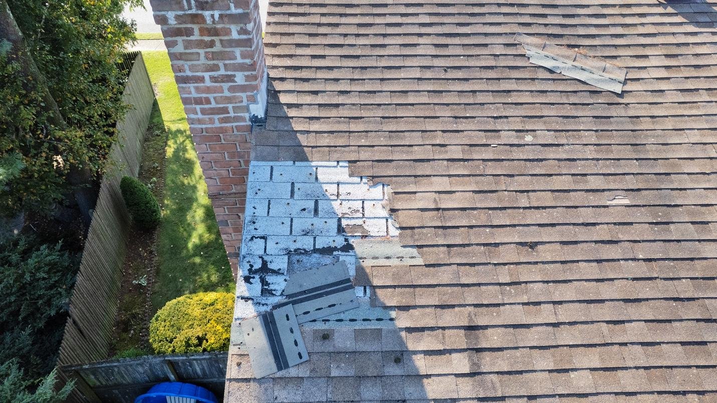
Roof Inspections Made Easier
Roofs are among the most vulnerable parts of a property, yet are often inspected the least. Drone roof inspection services solve this challenge by producing sharp aerial visuals that reveal damage invisible from the ground. These images help building owners identify missing shingles, flashing gaps, or areas where water collects.
Thermal sensors detect temperature inconsistencies that may signal insulation failure or leaks. By addressing these findings immediately, property managers prevent energy loss and interior damage while maintaining the roof’s structural integrity.
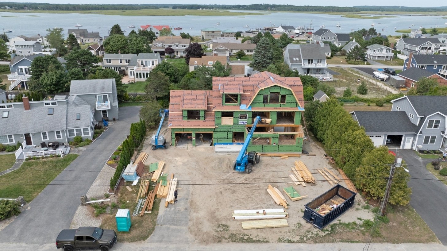
Construction Site Monitoring for Accuracy and Safety
Large projects involve multiple teams and moving parts. Over time, even small deviations can lead to costly rework. Construction site drone monitoring helps prevent these problems by capturing site progress in real time.
Drones can verify that materials are placed correctly, measure excavation depths, and confirm that construction follows design plans. They also detect safety risks such as unstable scaffolding or missing protective barriers. The collected imagery allows project managers to compare planned progress against actual results, ensuring resources are used efficiently.
Detecting Structural Damage Before It Spreads
In aging buildings or industrial facilities, structural wear can go unnoticed for years. Cracks, rust, and surface erosion often appear subtle until failure occurs. Drone cameras capture these signs at high resolution, making them easier to document and track.
Thermal and visual imaging combined can detect:
- Uneven heat distribution that indicates hidden moisture.
- Expansion joint failure.
- Cracks forming in concrete, steel, or roofing membranes.
With consistent inspections, engineers can monitor changes over time, predict potential failure points, and schedule maintenance proactively instead of reactively.
Ensuring Compliance and Safety
Drone inspections must follow federal and state guidelines. Every flight operated by Quality Aerials is conducted under the supervision of an FAA-certified drone operator who understands restricted airspace and safety regulations. Compliance ensures not only legal operation but also reliability in the data collected.
Working with licensed professionals eliminates risks associated with unauthorized flights or poor-quality data. For industries that depend on accuracy, such as construction, insurance, and agriculture, this compliance is essential.
When Prevention Becomes Profit
Preventive drone inspections directly influence profitability. A company that identifies a failing HVAC system early avoids service interruptions and lost revenue. A contractor who tracks construction alignment in real time prevents costly rebuilding. A farmer who spots water stress through aerial imaging saves a season’s yield.
Drones make these outcomes possible through clear visual evidence. The cost of one inspection is small compared to the financial losses caused by downtime or damage. As technology advances, the accuracy and affordability of drone inspections continue to improve, giving businesses and property owners a dependable tool for long-term savings.
The Growing Role of Data in Maintenance
Visual data collected through drones goes beyond pictures. It becomes measurable information that supports analytics and maintenance planning. Managers can compare current footage with previous reports to identify trends such as material degradation or shifting terrain.
These insights help predict when and where repairs are needed. Over time, businesses build a digital archive that strengthens decision-making and reduces emergency maintenance calls.
Drones on Construction Sites: Monitoring Progress in Real Time
Construction sites change daily. Equipment moves, materials shift, and deadlines depend on precision. Using construction site drone monitoring, project managers can view accurate progress updates without climbing scaffolds or halting operations. Drones capture aerial images and video from multiple angles, giving teams real-time insight into alignment, excavation depth, and material placement.
This oversight helps identify small discrepancies before they affect the entire project. When foundations or frameworks drift from specifications, rework becomes expensive. Drone data ensures problems are caught early, reducing both waste and downtime.
Benefits of drone monitoring on construction sites include:
- Regular visual documentation for reporting and compliance.
- Safe access to high or restricted areas without heavy equipment.
- Accurate measurement of stockpiles and grading levels.
- Immediate progress verification that supports faster approvals.
By replacing manual checks with drone inspection services, companies maintain tighter control over schedules and budgets.
Smarter Farming with Agricultural Drone Services
Agriculture depends on timing and observation. Farmers once relied solely on ground scouting to monitor crops, but that process misses subtle variations across large fields. Agricultural drone services now provide detailed aerial imagery that reveals stress patterns, irrigation problems, and soil inconsistencies long before they become visible from the ground.
Thermal and multispectral cameras detect temperature differences that indicate water shortages or disease. When analyzed, these images guide precise irrigation and fertilizer use. This data helps farmers prevent yield loss, cut input costs, and optimize resource allocation.
Typical agricultural drone operations deliver:
- Crop health mapping using thermal and visual imagery.
- Early detection of disease or nutrient deficiencies.
- Efficient spraying through targeted location mapping.
- Documentation for insurance or regulatory purposes.
For large farms, drone technology acts as both a diagnostic and planning tool, making maintenance predictive rather than reactive.
Mapping and Measuring with Drone Technology
In surveying and engineering, drone mapping and inspection services offer faster and safer results than traditional manual measurements. Drones can map acres of land in minutes, producing orthomosaic maps, contour models, and volumetric calculations. These outputs help engineers verify site elevations, calculate material volumes, and detect terrain shifts that could compromise future development.
Accurate mapping supports risk prevention. For example, early detection of soil erosion or drainage issues allows timely correction before roads or foundations are laid. Compared to ground surveying, drones minimize human error while reducing labor costs.
Professional operators ensure all data is geotagged and properly aligned for integration with CAD or GIS platforms. This seamless compatibility gives engineers and architects reliable data without repeated field visits.
Commercial Applications Beyond Construction and Farming
Drones now serve a wide range of professional sectors. Commercial drone services are used by utilities, real estate companies, and local governments to inspect large assets quickly and safely.
- Power lines and towers:Aerial imaging identifies corrosion, loose hardware, or vegetation encroachment.
- Bridges and industrial facilities:Drones capture close-up details of surfaces, joints, and cables for preventive maintenance.
- Solar fields and wind farms:Infrared imaging reveals malfunctioning panels or overheating components.
- Municipal inspections:City planners use drone services to assess infrastructure conditions and stormwater systems.
Each of these uses shares the same outcome: lower maintenance costs and greater operational safety. Drone data eliminates guesswork, allowing decision-makers to act with confidence based on real evidence.
Professional Standards and Certified Operation
Drones are only as effective as the people who operate them. Using a licensed drone pilot and an FAA-certified drone operator ensures compliance with aviation laws and safety standards. Certified professionals understand airspace restrictions, weather conditions, and privacy regulations.
Companies that follow proper certification protocols reduce liability while guaranteeing accurate results. This professionalism distinguishes established providers such as Quality Aerials, which combine field experience with technical expertise. Their compliance not only protects clients but also ensures each flight is efficient, legal, and repeatable for long-term monitoring projects.
Technology That Supports Cost-Efficient Operations
Drone inspections now combine multiple imaging modes, including thermal, RGB, and LiDAR. These technologies enhance accuracy by capturing both visible and hidden information. Thermal imaging identifies temperature irregularities that may signal leaks or electrical faults. RGB cameras provide visual confirmation, while LiDAR sensors create detailed elevation maps.
Such data integration allows top drone companies to deliver comprehensive reports that combine photos, 3D models, and measurements. Businesses gain a single, detailed overview instead of separate, inconsistent data sources. This precision supports better budgeting and planning, ensuring maintenance spending aligns with actual conditions.
The Long-Term Advantage of Preventive Drone Inspections
Early detection does more than save money; it extends the lifespan of buildings, machinery, and landscapes. Preventive inspections replace emergency repairs with planned maintenance, giving organizations control over both budget and safety.
The shift toward drone-based oversight represents a larger movement in asset management from reactive to proactive thinking. Drones provide the visibility needed to maintain that discipline without extra labor or disruption. Over time, this reliability builds stronger client confidence and improves return on investment.
The Takeaway: Preventive Drone Inspections Protect What Matters
Preventive drone inspections combine precision, safety, and speed to stop small issues from growing into costly failures. They help property owners maintain roofs and structures, assist farmers in monitoring crops, and enable construction managers to meet deadlines without compromise. By using certified professionals and reliable technology, businesses reduce maintenance risks and save substantial long-term costs. The ability to detect early warning signs is no longer a luxury; it is a smart business practice that protects investments, people, and productivity.
Prevent Costly Problems with Quality Aerials
With a team of experienced pilots and advanced imaging systems, Quality Aerials provides dependable inspection and monitoring services across Maine and New England. Our drone inspection services, construction site drone monitoring, and commercial drone services deliver clear, accurate, and actionable data. Each flight is handled by an FAA-certified drone operator and licensed drone pilot to ensure safety, compliance, and consistent results.
From roofs and structures to crops and industrial sites, our inspections reveal early warning signs before they become major expenses. Clients trust our precision and professionalism to keep operations running smoothly and assets protected.
Contact Quality Aerials today to detect problems early and protect your investment from costly surprises.
1. See Properties from a Whole New Angle
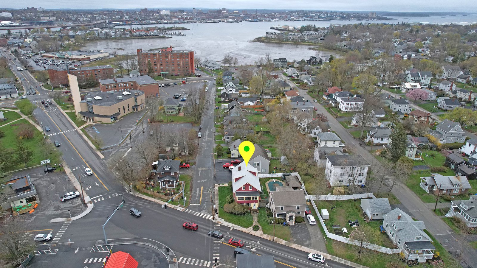
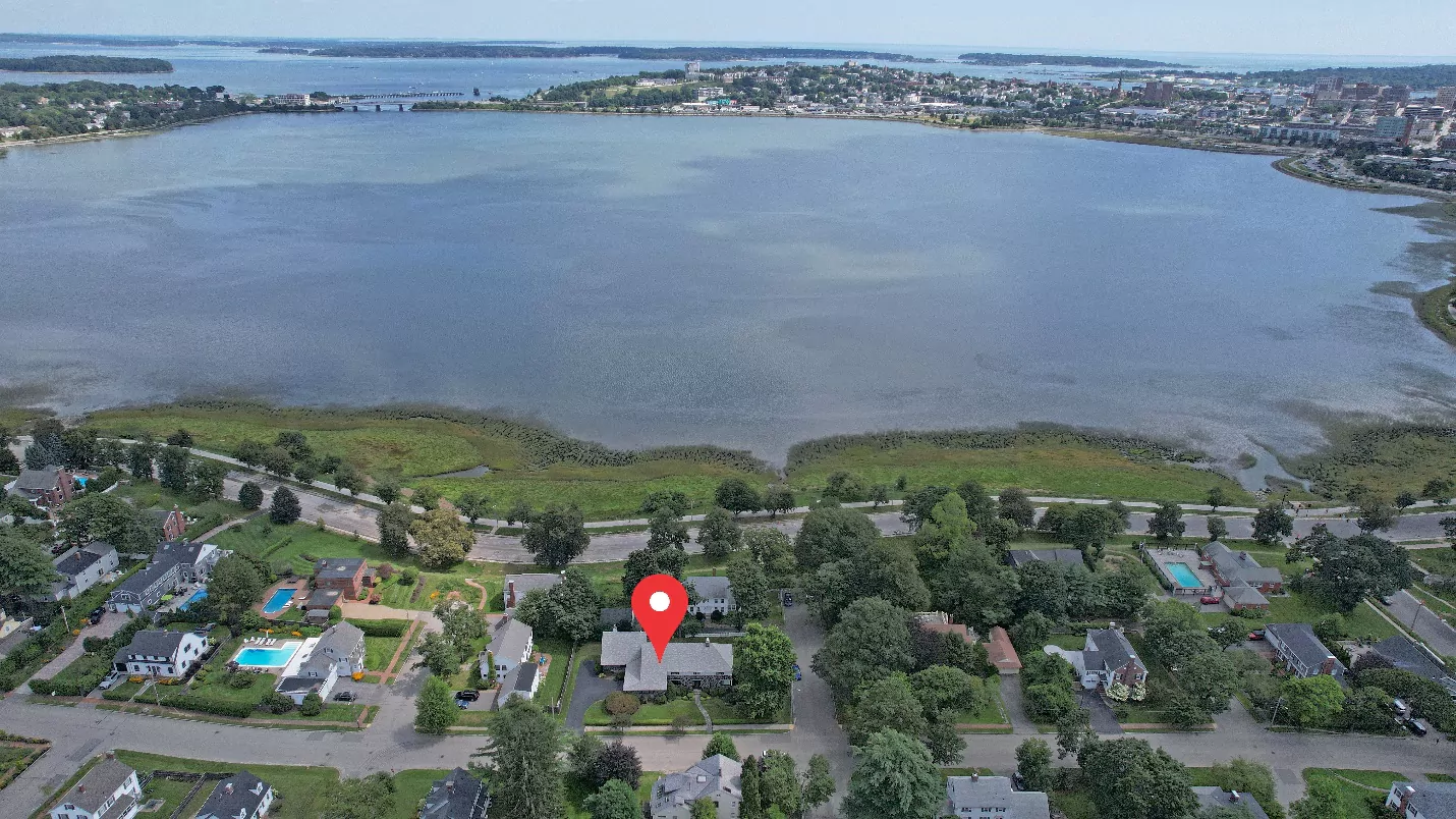
One of the most powerful advantages of drones is their ability to showcase properties from above. Ground-level shots can only do so much to capture a home’s presence, but a sweeping aerial view tells the whole story in a single frame. With high-resolution aerial photography, buyers can see the entire property layout, the surrounding neighborhood, and landscape features in context.
Imagine a prospective buyer scrolling through a listing and spotting a dramatic shot that reveals the house, backyard, and tree-lined street all at once. That single image immediately answers questions about lot size, privacy, and curb appeal. It creates an instant sense of place that traditional photography struggles to achieve.
Working with a professional drone photographer also ensures these images are crisp, well-composed, and optimized for marketing use. Realtors gain access to visuals that elevate their listings, while buyers gain clarity and confidence in what they are viewing. By showing properties from above, drones add both beauty and practicality, making every listing more memorable and compelling.
2. Showcase Location Clearly
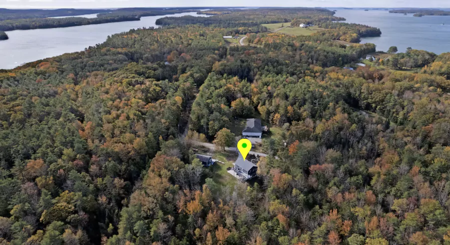
One of the toughest aspects of marketing a property is helping buyers grasp the true size of the land. Ground photos can only show so much, often leaving potential buyers uncertain about how big a yard really is or how far a property extends. This is where drone services in Maine make a dramatic difference. A single aerial shot can showcase an entire parcel of land, whether it is a spacious backyard, farmland, or wooded acreage.
For buyers, this perspective provides clarity. They can see where the property lines sit in relation to neighboring homes or open land. Realtors benefit as well, since buyers are less likely to be surprised or disappointed when they view the home in person.
With real estate drone photography in Maine, agents can also highlight the relationship between the house and the land it sits on. Is there enough space for a future pool or garden? Does the property have a long driveway that adds privacy? These details are immediately visible from above. By offering such comprehensive views, realtors ensure buyers see the full value of a listing, while sellers gain an edge in presenting their property in the best possible light.
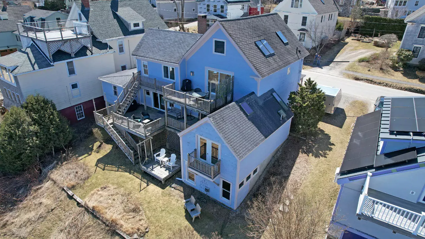
3. Pools, Patios, and Gardens that Sell Lifestyles
Outdoor amenities often seal the deal for buyers. Features like patios, decks, pools, and landscaped gardens tell a story of how life can be enjoyed at a home. Traditional ground photography might capture a portion of these spaces, but it cannot convey their full beauty and flow. Drone photography fills that gap perfectly.
From above, a pool sparkles in the sunlight, a patio looks inviting for summer gatherings, and gardens show their symmetry and design. These lifestyle-focused visuals appeal directly to buyers’ emotions, helping them picture themselves enjoying the space. By capturing these amenities with drones, agents can market not just the property itself, but the lifestyle that comes with it.
4. Boost Clicks and Keep Buyers Interested
In today’s digital-first market, real estate listings compete for attention in crowded online spaces. Properties that include visuals from above consistently stand out and perform better. Listings featuring drone photography often receive more clicks, more shares, and longer viewing times compared to those with standard ground-level photos.
When buyers see a striking aerial shot in a gallery, they are more likely to stop scrolling and engage with the listing. These images hold attention because they offer something unique that most properties cannot provide. By boosting online engagement in this way, agents not only generate more interest but also build stronger connections between buyers and listings.
5. Give Remote Buyers a Complete View
Relocating buyers often rely heavily on online resources before deciding which homes are worth a trip to see. With real estate drone photography in Maine, these buyers can experience a property virtually, gaining a realistic understanding of its layout and surroundings before they ever set foot on-site.
Aerial visuals provide context that ground photos cannot. Out-of-town buyers can see the distance to nearby roads, the relationship between the home and the landscape, and the overall flow of the property. This clarity saves time for both buyers and agents while helping sellers attract a wider audience. By offering comprehensive views, drone visuals remove uncertainty and give buyers confidence in pursuing a property.
6. Highlight Rooflines, Solar Panels, and Design Details
Unique architectural elements can set a property apart, but many of these features are difficult to capture from the ground. With the expertise of an FAA-certified drone operator, realtors can showcase rooflines, porches, solar panels, and custom design elements in ways that grab attention.
Drones also provide the added advantage of inspection capabilities. With drone roof inspection services in Maine, potential buyers and sellers can identify roof conditions, gutter lines, or maintenance needs without the expense and risk of manual inspections. These details help buyers make informed decisions while demonstrating that the property has been thoroughly evaluated. Highlighting architectural features from above creates a compelling listing while building trust through transparency.
7. Turn Listings into Dream-Home Experiences
Real estate marketing is not only about showing the facts of a property. It is also about sparking emotions that inspire buyers to take action. High-resolution aerial photography captures sweeping landscapes, golden-hour lighting, and dramatic angles that turn an ordinary listing into something extraordinary.
A cinematic overhead shot of a home framed by vibrant foliage or a sunset creates an instant connection. Buyers can picture themselves living there, hosting friends, and enjoying the lifestyle that comes with the property. These emotional connections are powerful drivers in the decision-making process. By using aerial imagery to craft dream-home experiences, realtors can move beyond simple marketing and create lasting impressions.
8. Grab Attention on Competitive Platforms
Online listing sites are saturated with properties competing for the same buyers, which makes presentation more important than ever. Homes displayed with standard ground-level photography can easily blend in, but those that incorporate aerials instantly stand out. With real estate drone photography in Maine, listings gain a professional edge that captures attention from the very first click.
Buyers scrolling through dozens of homes are far more likely to stop on a listing that offers something visually different. A dramatic aerial shot of a property, showing both the home and its surroundings, gives potential buyers a reason to linger and explore more photos. The combination of professionalism and creativity helps realtors differentiate their listings from the competition. In a crowded digital space, drone visuals act as a spotlight, helping a property shine and ensuring it does not get lost among the noise.
9. Elevate Even Modest Homes into Luxury Listings
Perception often influences how buyers value a property. A modest home photographed with basic images may appear ordinary, even if it has standout features. By contrast, adding polished aerial visuals can transform that same property into one that feels luxurious. This is the unique power of aerial photography services.
When buyers see sweeping views of a home framed by landscaping, neighborhood context, and architectural details, they perceive greater value. The property seems more desirable, and buyers begin to picture it as a premium option. This perceived upgrade can even influence how much they are willing to offer.
For sellers, this means a competitive advantage. Presenting a home in the most appealing way increases the chances of securing stronger offers more quickly. For realtors, it builds a reputation for going above and beyond in marketing. With aerial photography services, every home can be elevated, not only in visuals but also in how buyers connect with it emotionally and financially. What once looked ordinary becomes extraordinary, making a significant difference in the success of a listing.
10. Fast Turnaround Means More Listings Sold
Time is a critical factor in the real estate market. Agents often juggle multiple properties and need to present each one quickly without sacrificing quality. This is where drones add real value. With drone photography and aerial photography services, realtors can capture multiple listings in a short timeframe, ensuring fast turnaround while maintaining professional standards.
Aerial shots are not just quick; they are impactful. One session can provide enough material to showcase a property in full, from sweeping overheads to detailed views of outdoor amenities. Realtors then have high-quality visuals ready to upload, cutting down on delays and allowing them to move on to the next property. This efficiency helps agents serve more clients, handle a greater volume of listings, and build a reputation for speed and professionalism. The result is a win for both sellers and buyers who want properties marketed effectively without long waits.
11. Market Properties Year-Round
Maine’s natural beauty changes dramatically with the seasons, and buyers often want to see how a property looks throughout the year. From vibrant fall foliage to snow-covered landscapes and lush summer greenery, aerial visuals bring these transformations to life. With drone services in Maine, realtors can highlight the seasonal charm of a property and showcase its appeal in every condition.
These seasonal perspectives not only add variety to marketing materials but also help buyers imagine the home year-round. Whether it is a cozy winter retreat or a summer gathering place, drone footage captures the unique essence of each season, giving listings a timeless and versatile edge.
12. Assess Properties Quickly with Drone Roof Inspections
Before buyers make a decision, many want reassurance about the condition of the property. Drones provide an efficient way to address these concerns. With drone roof inspection services in Maine, agents and sellers can identify potential issues with roofs, gutters, or outbuildings without the need for risky manual inspections.
Working with an FAA-certified drone operator ensures that the footage is both accurate and safe to capture. These inspections save time and money while offering buyers added peace of mind. Realtors who include this level of detail in their marketing stand out for their thoroughness, helping clients feel confident about their investment from the very beginning.
13. Premium Marketing Without Premium Costs
In the past, capturing aerial views meant hiring helicopters or planes, which was expensive and impractical for most listings. Drones have changed that. Now, working with a professional drone photographer delivers luxury-level visuals at a fraction of the cost.
From sweeping overheads to smooth real estate aerial video tours, drones provide cinematic-quality marketing materials that were once reserved for high-end properties. This affordability makes it possible for agents to use aerials for everyday listings, giving them a consistent competitive edge. Sellers benefit from the elevated presentation, and buyers enjoy engaging, polished visuals that make the property stand out.
Partner with Quality Aerials Drone Photography Today
At Quality Aerials Drone Photography, you will find a family-run team with more than 20 years of experience capturing stunning visuals. With an FAA-certified drone operator, we specialize in real estate drone photography in Maine, offering high-resolution aerial photography, detailed inspections, and smooth real estate aerial video tours. Our expert aerial photography services ensure every listing looks polished, professional, and memorable.
If you are ready to market properties with confidence, trust Quality Aerials Drone Photography. Our team combines creativity, advanced technology, and reliable drone services in Maine to deliver results that stand out in today’s competitive market. Elevate your listings and impress your clients by partnering with the local experts in aerial and real estate photography. Contact us today!