Commercial property decisions have always depended on the quality of information available to the people making them. A facility manager scheduling a roof replacement, a developer evaluating a parcel, or an asset manager reporting on portfolio condition can only act as effectively as the data in front of them allows.
Traditionally, that data came from periodic walkthroughs, manual inspections, and static documents that quickly went out of date. Today, drone mapping services are changing that equation, giving commercial property stakeholders access to current, high-resolution aerial data that supports faster, more accurate decisions across every stage of a property’s lifecycle.
Aerial imagery, thermal data, and mapping technology now work together to provide a level of visibility into commercial properties that ground-based methods simply cannot match. The implications extend across maintenance planning, inspections, development feasibility, and long-term asset management, touching nearly every decision a property owner or facility manager makes.
Most commercial property management still operates on a reactive cycle. A roof leak prompts an inspection. A tenant complaint triggers a maintenance request. An insurance renewal requires updated documentation. Each of these events generates a snapshot of information that quickly becomes outdated as conditions change.
Drone mapping services introduce a different model. Instead of waiting for a problem to surface, regular drone inspection services create an ongoing record of property conditions that can be compared over time. A facility manager can track how a roof’s condition changes season to season, how landscaping and drainage evolve, and how construction or renovation progresses, all from a consistent aerial vantage point.
Michigan State University’s Infrastructure Planning and Facilities department has adopted drones for building inspections and surveys across its campus, using licensed drone pilots to support roofing inspections, masonry assessments, and their construction site surveys. The shift reflects a broader recognition that aerial data collection is not a one-time event but an ongoing capability that improves decision-making across every department that touches a property.
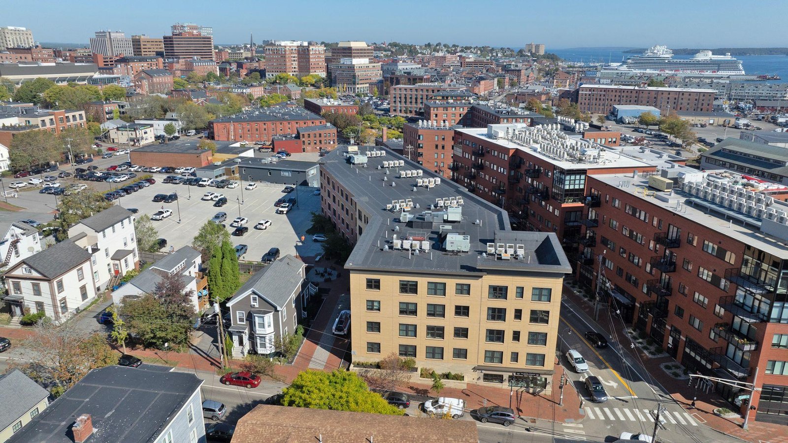
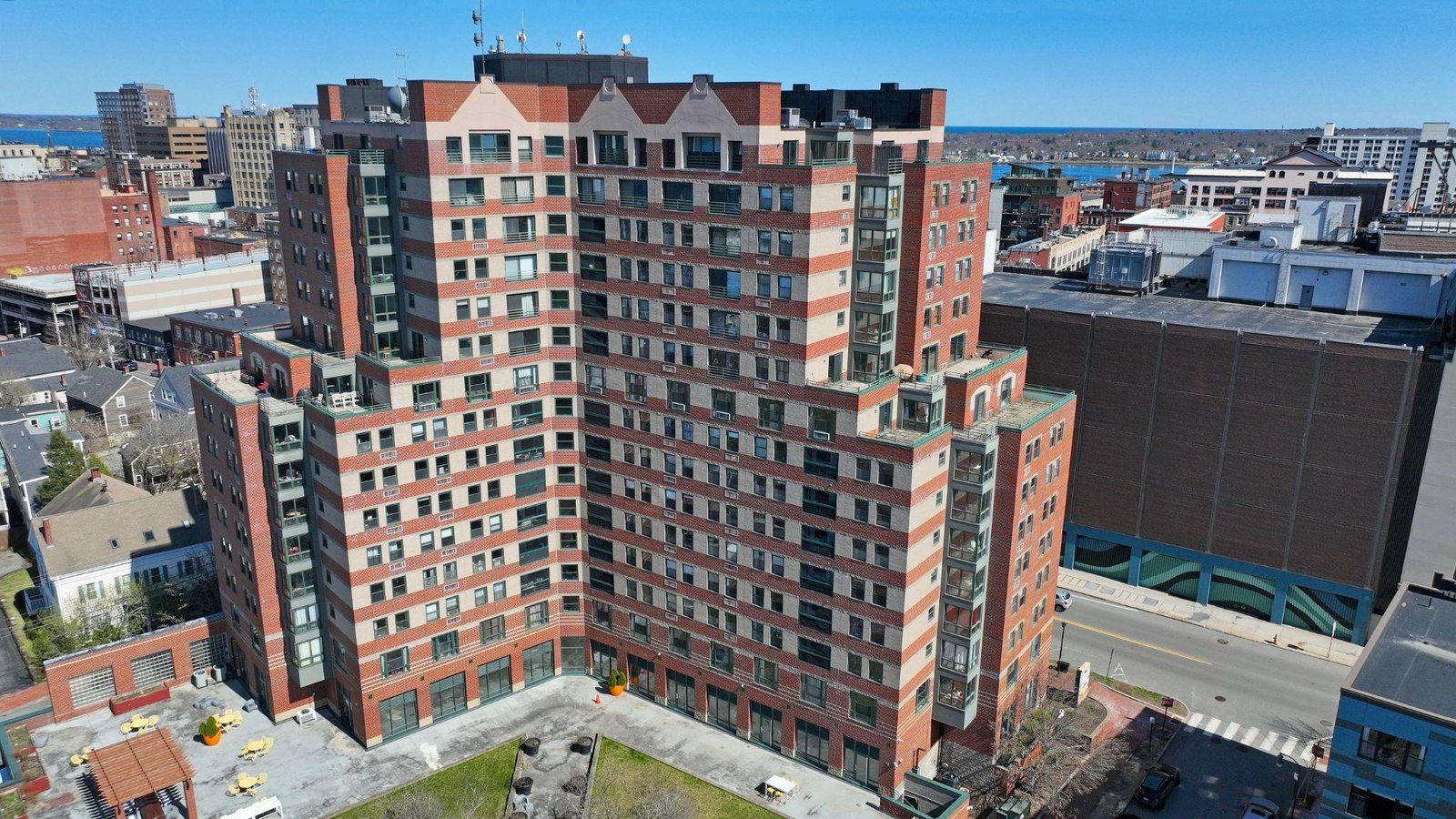
Visual documentation has always mattered for commercial properties, but the quality and comprehensiveness of that documentation have historically been limited by what a person on the ground could capture. High-resolution aerial photography changes that, providing a complete visual record of a property’s roofs, parking areas, landscaping, drainage systems, and structural elements in a single flight.
Maintenance planning depends heavily on this kind of documentation. Roof condition, in particular, is one of the most expensive and consequential maintenance considerations for any commercial property.
Identifying wear patterns, ponding water, membrane damage, or flashing issues early allows facility managers to schedule targeted repairs rather than waiting for a leak to force an emergency response. Drone roof inspection services captured at regular intervals create a documented history of roof condition that supports both maintenance scheduling and capital planning conversations with ownership.
Beyond roofs, drone mapping and inspection services capture parking lot conditions, exterior facade wear, landscaping health, and site drainage patterns across an entire property. For multi-building campuses or portfolios spanning several properties, this kind of comprehensive visual documentation would take days to compile manually. A single aerial survey accomplishes the same outcome in hours, with a level of detail that supports confident planning decisions.
Thermal imaging adds a layer of insight that visual aerial photography alone cannot provide. Buildings lose energy through their envelopes in ways that are completely invisible to the naked eye, whether that is heat escaping through poorly insulated sections of roof or wall, moisture trapped beneath roofing membranes, or HVAC systems operating inefficiently.
Thermal drone services reveal these issues by capturing surface temperature variations that correspond directly to building performance problems.
The reliability of this data depends on the quality of the thermal sensors and the proficiency of the operator capturing it. The National Institute of Standards and Technology has developed standard test methods for aerial drones that measure capabilities including maneuverability, visual, and thermal acuity, helping ensure that the thermal data collected by a drone system meets a consistent performance standard regardless of where or how it is deployed.
Facility managers responsible for commercial buildings, accurate thermal data translates directly into actionable maintenance priorities. A thermal survey can identify which sections of a roof have wet insulation, which walls are losing the most heat, and where HVAC equipment is underperforming, all without the cost and disruption of scaffolding or invasive testing.
Pinpointing thermal anomalies at exact locations allows building owners to target energy-saving improvements where they will have the greatest impact, rather than undertaking broad and expensive renovations across an entire facility.
The growing adoption of this technology reflects a broader market shift. According to Fortune Business Insights’ research on the global thermal drone market, demand for thermal-equipped drones continues to expand across commercial and industrial applications, driven in large part by their value in building inspections, energy audits, and infrastructure monitoring. For commercial property owners, this growth signals that thermal aerial data is moving from a specialized service into a standard part of how building performance is assessed and managed.
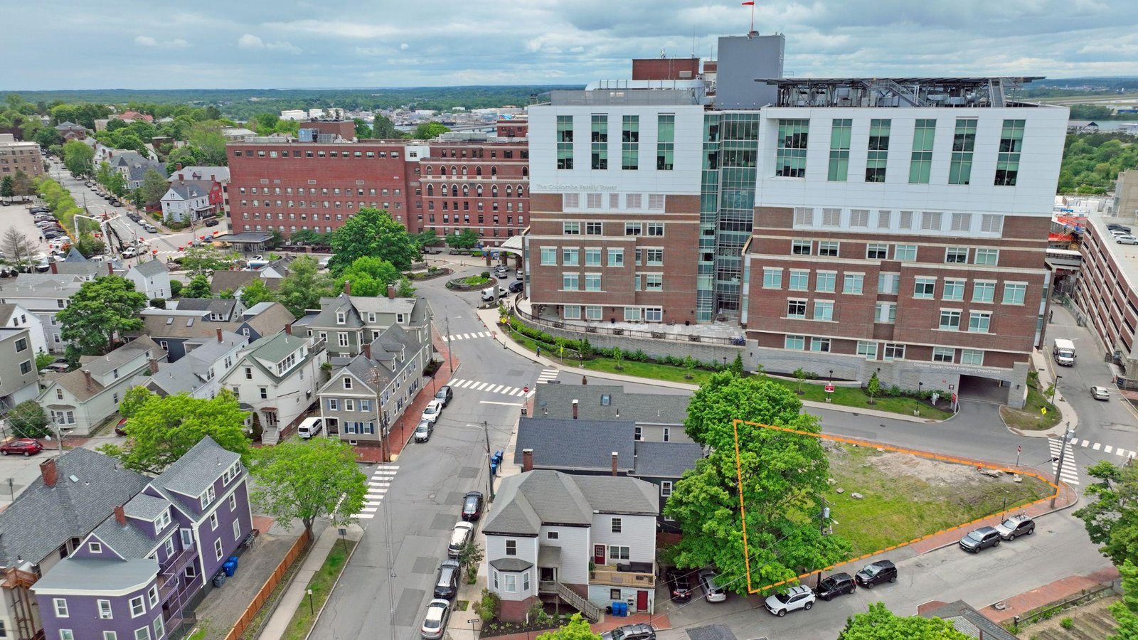
Property planning and development decisions depend on accurate, current information about site conditions, and drone mapping services deliver exactly that. Orthomosaic maps, digital elevation models, and 3D site models give developers and property owners a precise picture of topography, drainage, vegetation, existing structures, and access points across an entire parcel.
This data supports feasibility analysis for new construction or expansion projects, helping developers understand site constraints before committing significant capital to a project. Drainage analysis derived from aerial mapping can identify areas prone to flooding or poor runoff, informing site design decisions that prevent costly issues after construction. Construction site drone monitoring throughout the build supports accurate grading and earthwork planning, giving contractors reliable volume calculations from start to finish.
For existing commercial properties considering renovation or expansion, drone mapping and inspection services provide an accurate as-built record of current conditions. Discrepancies between original construction documents and actual site conditions are common, particularly for older properties, and aerial mapping resolves those discrepancies before they become costly surprises during construction.
Commercial real estate portfolios often span multiple properties across different locations, and maintaining consistent inspection standards across that portfolio is a persistent challenge. Sending inspection teams to physically walk every roof, parking lot, and building exterior across a portfolio is expensive, time-consuming, and difficult to schedule consistently.
Commercial drone services solve this problem by making comprehensive inspections faster, more affordable, and easier to standardize. A professional drone photographer working across a portfolio can survey multiple properties in a region over a short period, producing consistent, comparable data across the entire portfolio. Asset managers reviewing that data can quickly identify which properties require attention, prioritize maintenance budgets across the portfolio, and track condition trends over time.
This kind of portfolio-wide visibility is particularly valuable for real estate investment trusts, property management companies, and institutional owners managing dozens or hundreds of properties.
Decisions about capital allocation, refinancing, and disposition all benefit from accurate, current condition data that affordable drone photography and mapping services provide at a fraction of the cost of traditional inspection programs. Among the top drone companies serving this space, the ones that stand out are those combining technical precision with consistent, repeatable data collection.
Asset management is fundamentally about making informed decisions over the long term, whether that involves capital planning, valuation, insurance, or disposition strategy. Drone mapping services support each of these areas by creating a documented, time-stamped record of property conditions that informs decisions well beyond the immediate maintenance cycle.
The U.S. General Services Administration’s real property asset management framework emphasizes the importance of collecting and analyzing inventory data to support effective utilization, investment, and disposal decisions for real property assets.
The same principle applies to commercial property owners in the private sector. Accurate, current data about a property’s physical condition, infrastructure, and site characteristics directly informs decisions about when to invest in upgrades, how to position a property for sale, and how to allocate capital across a portfolio.
Insurance is another area where aerial data has become increasingly valuable. Detailed, time-stamped documentation of roof condition, site infrastructure, and building exteriors supports insurance claims, helps establish baseline conditions before storm events, and can influence underwriting decisions for property coverage. When disputes arise about the condition of a property at a given point in time, aerial data provides objective documentation that protects both owners and insurers.
For valuation purposes, drone footage for real estate and mapping data give appraisers and investors a clearer picture of a property’s physical condition and surrounding context than traditional photographs or site visits alone. A property’s relationship to nearby infrastructure, its site utilization, and its physical condition all factor into valuation, and aerial data captures all of these elements in a way that supports more informed underwriting and investment decisions.
A single aerial survey provides a valuable snapshot of a property’s condition, but the real analytical power of drone mapping services emerges when surveys are repeated at consistent intervals. Comparing imagery and thermal data from one quarter to the next, or one year to the next, transforms a static record into a dynamic timeline that reveals how a property is actually changing.
For facility managers, this kind of longitudinal data answers questions that a single inspection cannot. Is the roof deteriorating faster than expected? Has a drainage issue worsened since the last heavy rainfall? Are thermal anomalies in a building’s envelope expanding or stable? Repeat surveys captured under similar conditions allow direct comparisons that highlight trends, helping maintenance teams distinguish between cosmetic wear and developing structural problems that warrant earlier intervention.
Development and construction projects benefit from this same approach. Regular construction site drone monitoring throughout a build creates a visual timeline of progress that can be compared against project schedules and design documents.
Discrepancies between planned and actual progress become visible early, giving project managers the information they need to address delays or quality issues before they compound into larger problems.

Repeat aerial data also supports compliance and reporting requirements that many commercial property owners face. Zoning compliance, stormwater management plans, and environmental permits often require documentation that conditions on a site match what was approved or what is being reported to regulatory bodies.
Drone mapping and inspection services conducted on a regular schedule create the documented evidence needed to demonstrate ongoing compliance, reducing the administrative burden of manual site visits and providing a clear record if questions arise.
Hence, property owners managing multiple sites, building a library of historical aerial data also strengthens long-term planning conversations. Trends that might be invisible in a single survey, such as gradual drainage changes, vegetation encroachment, or slow degradation of pavement and roofing, become clear when viewed across a series of surveys spaced months or years apart.
That clarity supports more confident capital planning, helping owners prioritize investments based on documented trends rather than reactive assessments triggered by a visible failure.
The real value of drone mapping services for commercial properties lies in how these different data types work together. Aerial imagery documents current conditions. Thermal data reveals hidden performance issues. Mapping technology provides precise spatial context. Combined, these tools give property owners, developers, and facility managers a comprehensive, current picture of a property that supports better decisions across maintenance, inspections, planning, and long-term asset management.
As commercial property owners increasingly recognize the value of this data, aerial photography services delivered through regular surveys are becoming a standard part of property management programs rather than an occasional add-on.
The properties that benefit most are those where ongoing aerial data collection becomes part of a routine, creating a historical record that grows more valuable with each survey and supports decisions that would otherwise be made with incomplete or outdated information.
We’re Quality Aerials, a Falmouth, ME based provider of drone mapping services and aerial photography services, serving commercial property owners, developers, and facility managers across Maine, New Hampshire, and the greater New England area. From thermal drone services for building energy audits and agriculture to drone surveying and mapping, drone inspection services, and drone golf course management, we turn aerial data into the kind of clear, current information that supports smarter maintenance, inspection, and planning decisions. To talk through what aerial data could do for your property, reach out to us and let’s get the ball rolling.